Drought conditions still affecting our weather
Article content
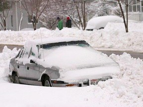
November saw the return of seasonal temperatures, while drought conditions still stubbornly persisted within the Ottawa Valley, as the region remained in the grip of a record dry spell.
This according to Environment Canada, which released its monthly Ontario weather review recently.
Geoff Coulson, warning preparedness meteorologist with Environment Canada, said the lack of precipitation continues to be the story of 2012 for Renfrew County, with last month being the driest on record.
He said the normal snow melt/rain amounts for November averages 67.2 mm, but for this year, Renfrew County received only a third of that; one weather station recorded only 21.8 mm of precipitation, while another collected even less, a staggering 14.5 mm.
This is the driest since 1986, when 24.9 mm of rain/snow melt was recorded.
Looking just at snowfall, normally some 23 cm should have fallen by now last month, but this year, a mere 10.9 cm did, and most of that melted.
“This has been the story across Ontario,” he said, with most regions in the province encountering lower precipitation amounts than is usual. This continues a pattern which started last winter, when between October 2011 to April 2012, 154.4 cm of snowfall was recorded, when the normal average is 228.5 cm. Complicating the problem was the temperatures were well above normal, with January to March averaging highs of 3.8 C.
“What was really striking about last winter is how consistently warmer it stayed,” Coulson said, and the lack of any really cold days, such as those sinking to -25 C or lower.
“But it is the dryness in many areas which stands out.”
However, he said there are signs this coming winter will be closer to what we think of as normal. November’s temperatures indicate this, as they averaged -0.3 C and -0.5 C based on the data measured at the two weather stations in the county. This is right where it normally would be, as the long time average is -0.4 C.
This year, there is no overarching driver to influence the weather, such as a La Nino or La Nina event, so he expects we will see a winter which would be about normal, punctuated with dramatic events, such as deep freezes, thaws and storms, the sorts of weather normally associated with the season. Because of this lack of a strong driver, forecast models will not be as reliable over the long term, but trends seem to indicate the return of a more normal winter.
“This is not going to be a hard winter, but one closer to normal,” Coulson said. “We are seeing signs of things settling into a more normal seasonal pattern.”
Coulson expects we could see the return of near normal amounts of snow and colder temperatures this winter.
The Ottawa Valley wasn’t alone in experiencing these conditions, as they persisted across Ontario.
Mean temperatures for the province were within the normal range, with northern Ontario slightly warmer than normal. Meanwhile, drier conditions were the norm across the province. In southwestern Ontario, 10 locations set records for lowest total precipitation for the month. Those locations which experienced significant snowfall events during the month received near-normal precipitation amounts as a result.
While Eastern Ontario was largely spared from being clobbered with major storms last month, a couple of winter weather episodes over northern Ontario and the first major snow squall event southeast of Lake Huron and Georgian Bay were the most notable severe weather events during November.
The first one began on the morning of Nov. 10 as a low-pressure system moved northeastward into Nebraska. Some freezing precipitation along the northern edge of the system then began in portions of northwestern Ontario. A day later, the storm had spread a messy mixture of snow, ice pellets, freezing rain and rain across the areas north of Lake Superior and into northeastern Ontario. Geraldton received approximately 20 mm of all types of precipitation combined. The precipitation gradually faded over the northeast on the afternoon of Nov. 12.
The second large winter storm affecting northern Ontario during the month moved into the Fort Frances area from the Dakotas on the morning of Nov. 22. By late in the day, the storm had moved northeast of Lake Superior. What began as rain in the Thunder Bay area that evening changed over to snow during the early morning hours of the next day. By the time the snow began to diminish on the morning of Nov. 23, Thunder Bay had received 20 to 25 cm of snow. This resulted in Friday school cancellations.
Areas north of Lake Superior also received significant snowfalls on Nov. 23, but it was Kapuskasing that recorded the highest amounts: more than 43 cm. Road conditions across the north were impacted by the weather system and these poor conditions were a factor in a serious multi-vehicle collision in the Timmins area that resulted in three fatalities.
In the wake of this storm system, arctic air flooded down over the open and warmer waters of Lake Huron and Georgian Bay. This set up a classic lake-effect snow situation. Fortunately, the heaviest bands of snow did not remain over any one single area for a prolonged period of time.
However, from Nov. 23 to Nov. 26, winds from the west and northwest sent bands of snow over the Bruce Peninsula and over areas around southern Georgian Bay and Lake Simcoe. As the flurry activity died down late on Nov. 26, the Wiarton area had received roughly 36 cm, the Barrie area had picked up some 25 cm and areas to the north of Lake Simcoe had received local amounts of 20 cm or more.
Stephen Uhler is a Daily Observer multimedia journalist